The Enchanting Sea Monsters on Medieval Maps
Fictitious animals on 16th and early 17th century maps hint at how people’s perception of the ocean has changed over time
/https://tf-cmsv2-smithsonianmag-media.s3.amazonaws.com/filer/20131015090018Sea-Swine-56.jpg)
The sea has been the stage for monstrosities and strange tales since antiquity. And, why not? Unlike land, the ocean is constantly shifting and moving, with currents that could carry a ship off course and storms that threaten wrecks. Even the substance itself, seawater, is often cold and dark, and deadly to drink in quantity. So, what of the creatures that were thought to live there?
The sea monsters that populated European medieval and renaissance imaginations—fierce-toothed animals battling in the waves, long serpents wrapped around ships, torturously beautiful sirens and a wide assortment of chimeric beings—are the subject of two new books. Sea Monsters on Medieval and Renaissance Maps, by Chet Van Duzer, and Sea Monsters: A Voyage around the World’s Most Beguiling Map,
by Joseph Nigg, both focus exclusively on illustrations, several of which are included here, of such monsters on old maps.

An ichthyocentaur (parts human, horse and fish) plays a viol on a map of Scandinavia from the 1573 edition of Ortelius’s Theatrum orbis terrarum. The sea surrounding Scandinavia showed sailing ships and this traditionally peaceful ichthyocentaur, perhaps suggesting safe passage. Reprinted with permission by the British Library and the University of Chicago Press.
More than mere marginalia and playful illustration, cartographers drew sea monsters to enchant viewers while educating them about what could be found in the sea. Most of the decorated maps weren’t used for navigation, but rather were displayed by wealthy people. That doesn’t mean the monsters were purely ornamental inventions though. “To our eyes, almost all of the sea monsters on all of these maps seem quite whimsical, but in fact, a lot of them were taken from what the cartographers viewed as scientific, authoritative books,” said author Chet Van Duzer in a podcast with Lapham’s Quarterly. “So most of the sea monsters reflect an effort on the part of the cartographer to be accurate in the depiction of what lived in the sea.”
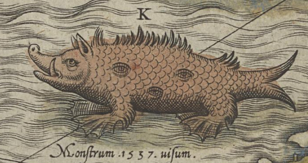
This sea pig, which was compared to heretics that distorted truth and lived like swine, lived in the North Sea on Olaus Magnus’s 1539 Carta Marina, a lushly illustrated map that inspired many after it. Public Domain.
There was a long-held theory, going back to at least the first century with Pliny the Elder’s Natural History, that every land animal has an equivalent in the ocean. There were thought to be sea dogs, sea lions, sea pigs—you name it. Some of these are now the names of real animals—sea lions are eared seals and sea pigs are deep-water sea cucumbers (tube-like relatives of sea stars) with legs. But the medieval imaginings were the literal hybrid of fish with the known land animal.
Two whales attack a ship as sailors try to scare them away by tossing barrels and playing a trumpet on Olaus Magnus’s 1539 Carta Marina. Reprinted with permission by the British Library and the University of Chicago Press.
Some of the illustrations, however, are closer to real animals but warped into monstrous forms. Whales were typically drawn with beastly heads, like a cross between a wolf and a bird, with tusks or large teeth and waterspouts. Despite their generally gentle nature, they were often drawn attacking ships. While it’s unlikely that such confrontations were frequent, it’s easy to imagine the fear welling up when a sailor spotted the back of a whale longer than his ship rise above the waves. If it jumps from the water, is it on the attack?
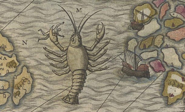
Polypus (meaning “many-footed”) was used to describe many animals, from the lobster to the centipede to the octopus. While Olaus Magnus (1539) drew a giant lobster here, his text describes an octopus, showing the true confusion about what lived in the sea. Public Domain.
These uneducated sailors were the main sources for artists and writers trying to describe life in the ocean. So, their reports of monsters—from the singing sirens that lure sailors to jump to their deaths to the the lobster-like “octopuses” and various serpents and worms—became the basis of natural history texts and drawings on maps. These maps then helped perpetuate the life of these creatures, as they inspired travelers on the dangerous sea to confirm their existence.

A siren admires herself in a mirror—a sign of her vanity—amongst ships in the Southern Ocean on Pierre Descelier’s map from 1550. Other monsters can be seen on the surrounding land. Reprinted with permission by the British Library and the University of Chicago Press.
However, at the end of the 17th century, sea monsters start to disappear from maps. European understanding of science was growing, and the printing press made the spread of realistic images easier. “As technology advanced, as our understanding of the oceans and navigation advanced, more emphasis was placed on human’s ability to master the watery element: to sail on it and conduct trade on it,” Van Duzer told Lapham’s. “And thus images of the dangers of the sea, while they certainly did not immediately disappear from maps in the 17th century, became less frequent over time, and images of ships became more common.”
There were still illustrations on maps, but they were far more pragmatic. Ships indicated areas of safe passage, while drawings of fish and whales showed good fishing areas. On one map from the early 17th century, vignettes illustrated how to kill and process a whale. “Whales, the largest creatures in the ocean, are no longer monsters but rather natural marine storehouses of commodities to be harvested,” wrote Van Duzer. Some of the mystery is gone as the sea becomes another resource rather than a churning darkness to be feared.

Long before they disappeared from maps, sea monsters were repurposed for politics. Here, King Manuel of Portugal rides a sea creature off the Southern tip of Africa, symbolizing Portugal’s control of the seas, on Martin Waldseemüller’s 1516 Carta Marina. Reprinted with permission by the British Library and the University of Chicago Press.
Just when you think that we’ve lost that sense of awe at the sea, captured in these old maps and texts, we are reminded that much remains to be discovered in the ocean. This year, both the giant squid and the 15-foot megamouth shark were filmed for the first time, and there is still plenty to learn about each. We’re still dazzled by bioluminescent light displays in the deep, or the surreal, shimmering movements of schools of millions of tiny fish. The awe continues—it’s just based on fact rather than fantasy.
 Learn more about the ocean at the Smithsonian’s Ocean Portal.