This Is Mars in Extremely High Resolution
French designer Xavier Barral pored over 30,000 images taken by the Mars Reconnaissance Orbiter’s HiRISE camera, selecting the most appealing for his book
/https://tf-cmsv2-smithsonianmag-media.s3.amazonaws.com/filer/Collage-Mars-closeups.jpg)
On March 10, 2006, seven months after an Atlas rocket boosted it into space from Cape Canaveral, Florida, the Mars Reconnaissance Orbiter fell into place in the Red Planet’s orbit. Since then, the $720 million spacecraft has been hovering 150 to 200 miles above the surface of Mars, surveying for suitable landing sites for future missions and any evidence that water once flowed there.

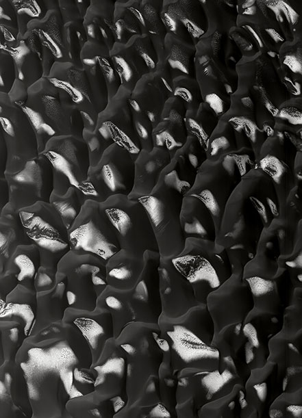
Field of Dunes in the Proctor Crater, LAT: -47.2° LONG: 33.9° © NASA/JPL/University of Arizona “Hundreds of black-sand dunes of basaltic composition have accumulated on the floor of the Proctor crater,” writes Mangold. “In winter, because of the relatively high latitude (47° south), these dunes are covered by frost and carbonic ice, in particular on the polar flanks deprived of sunlight, thus creating a sharp contrast in tone.”
On board the MRO is one of the heftiest and most adept cameras ever to document a planet’s terrain. The HiRISE, short for High Resolution Imaging Science Experiment, has captured more than 29,000 insanely-detailed images—of a highly-concentrated 1.8 percent of the surface of Mars—in seven years.

Region of the Polar South, LAT: -86.8° LONG: 15.7° © NASA/JPL/University of Arizona “The terrains of carbonic ice of the southern vault have been eroded, leaving circular depression, by sublimation—except when the terrains are heterogeneous and inclined, in which case arabesques of small cliffs are formed,” explains Mangold.
“The images taken by HiRISE…reveal all of the beauty of Mars,” writes Alfred S. McEwen, a planetary science professor at the University of Arizona and principal investigator for HiRISE, in This is Mars, a new book published by Aperture. “While their quality and precision are indispensable for the scientific success of the MRO’s mission, they also faithfully capture the planet’s mysterious splendor.”
“Physical processes have produced pleasing patterns on its surface, such as polygons, stair-stepped layers, flowing sand dunes, meandering river deposits, lava flows with spiraling coils, explosive impact craters with dramatic radial patterns, eroded mesas with vertical cliffs, layered ice deposits over the poles, icy flows over the middle latitudes, dust deposits with strange textures, and,” he continues, “sharp-rimmed gullies that look like they formed just yesterday (some of them did).”

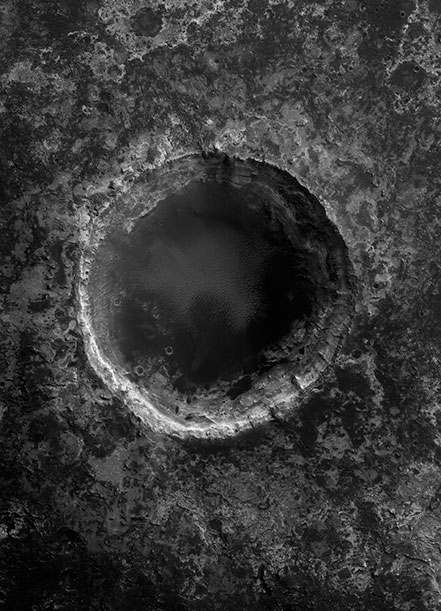
Crater Having Impacted the Strata of the Plateau Mawrth Vallis, LAT: 24.3° LONG: 340.7° © NASA/JPL/University of Arizona “In this case the strata at the edge of the crater are composed of phyllosilicates (from the Greek phyllis, meaning “sheet”), which are also called clay minerals. These minerals are formed by the transformation of the liquid water in primary minerals (silicates) into silicate sheets containing water molecules, commonly known as clay. These are among the most interesting mineralogical testimonies of the ancient, humid past of the planet Mars,” according to Mangold.
The wonder was certainly not lost on French photographer, designer and editor Xavier Barral. Barral grew up in the shadows of the Paris Observatory and has been interested in space for decades. For the purposes of compiling This is Mars, a half-art, half-science glossy coffee table book, he approached NASA and was granted access to a massive archive of Mars images.
Barral scanned multiple times the roughly 30,000 photographs taken by the MRO—an equivalent of more than 300,000 miles were he to have walked the distance represented by each photo by foot. Along the way, he consulted with McEwen and other scientists, including astrophysicist Francis Rocard and geophysicist Nicolas Mangold, who helped identify and explain the geological features he saw. But, first and foremost, Barral sought compellingly composed photos—he hand-selected about 150 images to feature in his book.

Region of the Polar South, Deep Incision in the Polar Sedimentary Strata, LAT: -86.1° LONG: 172.1° © NASA/JPL/University of Arizona “The sedimentary strata are mostly composed here of ice from water and not carbonic ice. The fractures that traverse these strata come from strong, seasonal thermal variations that can reach close to 100° C (212° F),” writes Mangold.
Each black-and-white photograph in the book covers a swath of Mars 3.7 miles wide, and yet no two are alike in their swirls, ridges, pock marks, blotches and striations.
“I can’t prevent myself from seeing references to all of art history,” says Barral. “It is all intertwined. All these geological shapes have artistic qualities.”
The designer extracted the most surprising points of view, in his opinion, from the MRO’s collection. “What surprises me in these observations of Mars is the unsuspected shapes of the landscape, showing 4.5 billion years of history,” he says. “These observations bring us closer to the remote—in time and in space—and fuel our imagination.”

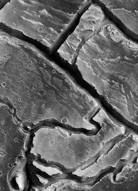
Valles Granicus, LAT: 27.369° LONG: 135.557° © NASA/JPL/University of Arizona Here, Mangold explains, one is looking at “a labyrinth of canyons hollowed out by outflows on a volcanic plateau near the Elysium Mons volcano.”
In his book, Barral wanted to replicate his experience of coming to these enigmatic compositions, unversed in the geology of Mars, for his viewers, and so reproduced the photographs at a fairly large scale, nearly 13 inches by about 9 inches, without any labels. Only in the back of the book does he provide a key, detailing the actual landmarks and their geographic coordinates.
“At the end of this voyage, I have gathered here the most endemic landscapes. They send us back to Earth, to the genesis of geological forms, and, at the same time, they upend our reference points: dunes that are made of black sand, ice that sublimates,” writes Barral in the book. “These places and reliefs can be read as a series of hieroglyphs that take us back to our origins.”
/https://tf-cmsv2-smithsonianmag-media.s3.amazonaws.com/accounts/headshot/megan.png)
/https://tf-cmsv2-smithsonianmag-media.s3.amazonaws.com/accounts/headshot/megan.png)