What Would You Do With A Drone?
As the potential drone applications grow, so does the build-your-own drone movement
/https://tf-cmsv2-smithsonianmag-media.s3.amazonaws.com/accounts/headshot/Screen_Shot_2014-01-27_at_12.05.16_PM.png)
/https://tf-cmsv2-smithsonianmag-media.s3.amazonaws.com/filer/87/d8/87d8524e-3932-499c-92bc-b9d75101b20c/dsc_1241.jpg)
It’s probably safe to say that drones will play a key role in our future.
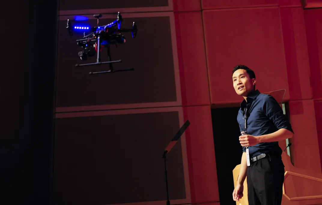
“People have long been fascinated by the ability to see from the sky,” says Christopher Vo, a graduate researcher at George Mason University in Fairfax, Virginia. Like the hot-air balloons, zeppelin, and airplanes before them, drones allow humans to look at their world from a different perspective. Vo spoke about the potential for personal drones at the Smithsonian’s The Future Is Here conference in Washington, DC. Exactly what role these flying robots will play in our future remains to be seen.
Drone technology was developed for military use, but a growing number of alternatives have popped up in the last decade. Citrus farmers now use drones to monitor crops. Conservationists keep tabs on endangered species, as well as any poachers. Police departments are thinking of using them in rescue and hostage situations. Drones have even helped shoot some major feature films, including Man of Steel and Skyfall. “The technology has become smaller, easier, safer, more accessible, and mainstream,” says Vo.
So, what’s changed? Two trends have driven this expansion: open source technology and the “makers” or DIY movement.
The technology has gotten better and more readily available. Drones and the sensors used to optimize them have gotten smaller. The push to open source technology and coding has made software to program drones readily available. “Because the software is open source, people can download it and use it as is,” says Vo, who develops and optimizes algorithms for use in drones as part of his research. “They don’t have to tweak it at all if they don’t want to.” If people tweak their code for niche drone applications, they can publish it online for another coder to use.
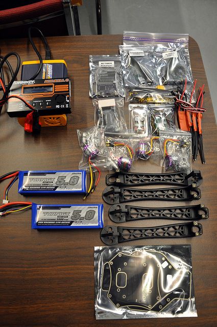
The same makers movement that spawned Etsy includes drone hobbyists with a desire to build their own flying robots. Through an organization called the DC Area Drone User Group, Vo works with a “makers space” NovaLabs in Reston, Virginia. It’s exactly what it sounds like: a place where people can use tools to make stuff. There, he teaches build-you-own drone workshops. Building a basic drone is actually fairly straightforward. “The drone that they would build with the recommended parts is kind of like a roadster,” says Vo. “You buy all of these parts off the shelf, and then you put them together just like a hotrod.” The parts could cost as little as a few hundred bucks, but costs can increase by a lot when photo or video cameras are added.
These drones are far different from the ones designed for military purposes. “A drone is basically a model airplane with a smart, autopilot brain,” says Vo. When he and his compatriots get together to test-fly their creations, it’s not different than flying a kite, really, and in fact most the drones they build are about the size of a kite. Drone enthusiast groups are popping up across the country, and groups like DIY Drones and the Drone User Network have created online communities as well.
Most people who come to these workshops use their drones for aerial photography or videography—to survey crops, take real-estate and wedding photos, see who’s at the end their driveway, check their gutters, or just take a selfie.
Before the technology can truly proliferate, the Federal Aviation Administration is in the process of devising a regulation plan, especially for commercial drones, that eases public fears of drones and prevents them from colliding with piloted airplanes. Currently, the FAA handles commercial drone use on a case-by-case basis, and breaking the rules comes with a hefty fine. Fears of unregulated surveillance and privacy issues need to be addressed and relieved before drones start delivering us groceries or even as, Vo demonstrated at the conference today, a bottle of water.
Congress has given the FAA until September 2015 to figure out what to do about commercial drones, but the organization forecasts that by 2018 around 7500 drones will fly across U.S. skies. According to the Association for Unmanned Vehicle Systems International, that translates to 100,000 new jobs and 100 billion dollars flowing into the economy. Some companies already have plans to incorporate drones into their businesses practices. Most notably, Amazon announced plans last year to pursue using door-to-door drones for delivery. Along similar lines, future drones could transport vaccines and medicines to remote areas.
It’s easy to imagine a future filled with drones buzzing about. What will the drones of the future look like? Vo thinks they’ll be quieter; camera technology will shrink and so will battery technology; tomorrow’s drones might also be autonomous. As the tech gets better and better, more and more applications arise.
What would you use your drone for?
/https://tf-cmsv2-smithsonianmag-media.s3.amazonaws.com/accounts/headshot/Screen_Shot_2014-01-27_at_12.05.16_PM.png)