Blogs

  • News
  • |
  • Art
  • |
  • History
  • |
  • Food and Travel
  • |
  • Science
Food & Think

A heaping helping of food news, science and culture

Off the Road

The travel adventures of a nomad on the cheap


December 3, 2012

Have GPS Devices Taken the Fun out of Navigation?

It took many, many long sea voyages and much tedious charting to produce the first crude maps of the world. Today, travelers are increasingly abandoning even the best maps in favor of electronic navigation devices. Photo courtesy of Flickr user Norman B. Leventhal Map Center at BPL.

It took explorers centuries of great effort to make the first crude sketches of the world and centuries more to polish and perfect them.

But in just ten years, sales demand for paper maps appears to have dipped markedly, and it seems these formerly essential tools of travel could be going the way of the sextant and chronometer as travelers rely increasingly on electronic navigation devices to get them where they want to go. In Pennsylvania, printers who once produced three million road maps a year now make just 750,000. AAA, too, has observed a decline in customer use of maps. And even print-out directions that lead from point A to point B—which I always thought was cheating, anyway—seem now to be a figment more of memory than of practice as that robot voice from the dashboard becomes an increasingly ubiquitous component of driving anywhere.

If we are, in fact, ditching the map for flashier gear, will we be better off? Maybe not. A study conducted in Tokyo found that pedestrians exploring a city with the help of a GPS device took longer to get places, made more errors, stopped more frequently and walked farther than those relying on paper maps. And in England, map sales dropped by 25 percent for at least one major printer between 2005 and 2011. Correlation doesn’t prove causation—but it’s interesting to note that the number of wilderness rescues increased by more than 50 percent over the same time period. This could be partly because paper maps offer those who use them a grasp of geography and an understanding of their environment that most electronic devices don’t. In 2008, the president of the British Cartographic Society, Mary Spence, warned that travelers—especially drivers—reliant on electronic navigation gadgets were focusing mainly on reaching a destination without understanding quite how they got there. And Tom Harrison, a cartographer in California, told me recently in an interview that he feels digital technology usually does a clean job of directing travelers where they want to go—but without quite showing them where they are.

“Trying to see and understand the big picture on your phone or laptop usually isn’t possible,” said Harrison (who also noted that he has not observed a decline in sales of waterproof topographic maps via his website). “There’s too much zooming in, scrolling down, losing your bearings.” At best, hand-size GPS screens show one “the here and the now,” he said, while only paper maps can reliably “show us where we are and also what’s around us.”

Using real printed maps also demands—and can help users develop—critical thinking skills.

“You look at the map for a minute,” Harrison said. “Then you say, ‘I’m here, and I’m going there. What’s the easiest way?’ But with GPS in the car you don’t even have to think about it anymore.”

The shift to full reliance on navigational technology is happening at sea, too. Grant Headifen, the founder of the online sailing academy NauticEd, says sailors are increasingly relying on GPS systems while neglecting to learn what he calls “the fundamentals”—the basic skills of navigating only by charts, compass, sky and the mighty strengths of the human brain.

“You need to be able to say, ‘If north is straight ahead of me, then east is to my right,’ and ‘If point A is 50 miles ahead and we’re moving this fast, then this will be our estimated time of arrival,’” said Headifen.

This GPS screen displays current latitude and longitude with perfect accuracy—but sailors who rely solely on such technology might be missing out on the fun of celestial navigation. Photo courtesy of Flickr user le Korrigan.

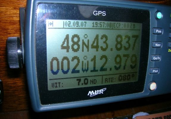
Reliance on electronics, which operate under the guise of flawlessness, is “very dangerous,” Headifen says—mainly because navigation charts may themselves be drawn incorrectly. For instance, a GPS system may guide you with perfect accuracy past a treacherous seamount—but if that reef was originally mapped incorrectly, the GPS system could actually be guiding you into a million-dollar accident. Headifen cites a time that he was sailing off the coast of Croatia. Because of incorrectly drawn charts, his GPS system placed his location at roughly 300 meters inland among the coastal olive orchards. Another time, a sailing companion with his eyes glued to his iPhone muttered directions to Headifen. “In 50 meters we want to veer left,” the man said. Headifen replied, “Um, look away from your phone for a minute, and look ahead of us.” A rock stood precisely in the course the iPhone recommended.

Harrison, too, has noted previously to reporters an important difference between being “precise” and being “accurate,” both of which a GPS device can be at once by pointing a tech-tuned traveler straight to the wrong place. 

In spite of the growing prevalence today of navigation technology, enough people remain interested in traditional navigation that Headifen offers a course on celestial navigation. This brilliant science has its roots in ancient Arabian cultures of the desert, where travelers long ago determined their location on Earth by watching the heavenly bodies above. For travelers in the Northern Hemisphere, the North Star, or Polaris, made determining latitude a piece of cake: The star’s distance above the horizon in degrees equals the viewer’s degree distance north of the Equator. Thus, when sailors left port in the old days, they often remained at a given latitude by watching Polaris and appropriately adjusting their course. They knew that by following that line, they would reach home again. (Determining longitude was a much more difficult endeavor, and would only become relatively easy with the invention of the chronometer in the late 1700s.)

Still, navigation remained challenging. Sailing expeditions often had a crew member whose specific job was to navigate—and these were among the most skilled people on the seas. They were familiar with the stars, the ecliptic of the Sun and also the orbital path of the Moon. They carried a variety of beautiful and ingenious tools over the years, like the astrolabe, octant and quadrant. But the sextant has remained the most used. It’s actually based on rather simple geometry, allowing one to sight a point in the sky—usually the Sun or a star—and measure its distance from the horizon. Combined with the chronometer and basic star charts, a good navigator could track a vessel’s location exactly—though this was a very difficult task. In fact, if executed correctly and accurately, celestial navigation is flawless—for our place on Earth is written in the stars; one must simply have the tools and skills to read the sky.

This simple homemade contraption, consisting of a straw, a protractor, a string, a weight and tape, can be used to measure latitude. Photo by Alastair Bland.

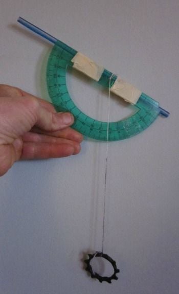
Celestial navigation made easy: Even if we’re too lazy to read maps anymore, reading the stars can be fun. Measuring latitude is a basic calculation and an engaging way to track your progress should you decide to tackle a long-distance north-to-south hiking or cycling route. Before your next trip, try this: Fix a sturdy plastic straw to the straight edge of a protractor. This device, familiar, I hope, from high-school geometry classes, should have a pinhole at the center of the baseline. To this point, tie off 12 inches of string and fix a heavy nut or bolt to the other end. Pack the contraption along. On your first night out, hold the device with the protractor facing down, look through the straw and aim it at Polaris. When you are able to see this conveniently located star, pinch the string to the side of the protractor. If the string is crossing, say, the 53-degree mark, subtract that number from 90. The answer, 37, is your latitude. If the next night you get a reading of 54, meaning 36 degrees latitude, that means you have traveled 69 miles (the distance between latitude lines) toward the Equator. In the Southern Hemisphere, there is no equivalent of Polaris, and celestial navigators may need to rely on a measurement of the Sun at its zenith to determine latitude. This website describes how.

Navigation of tomorrow: While no-brainer navigation systems currently dictate directions to drivers, tech companies are busy designing the next step in the road to laziness: automated vehicles. Nevada, Florida and California have already legalized driverless cars. While these marvels of technology aren’t yet publicly available, they do exist. Google has been testing one that reportedly had gone 300,000 miles, and counting, without an accident. What’s astonishing is that the machines seem to work perfectly well. What’s scary is the thought of them failing—of missing an offramp by ten feet, of not recognizing a pedestrian, of misinterpreting an obstacle in the road, or otherwise failing where a human mind might not.


***

Sign up for our free email newsletter and receive the best stories from Smithsonian.com each week.

11 Comments »

  1. Darrell Styner says:

    You seem to have made a mistake in the “navigation made easy” paragraph. Surely the angle to the Polaris increases as your latitude increases. If you subtract the measurement from 90, you get an inverse relationship, which can’t be right. Isn’t your latitude simply equal to the measured angle to Polaris?

  2. Sparafucile says:

    No. The author got it right. If you’re standing on the North Pole, your protractor will read 0 degrees, as you’re looking straight up at Polaris. Yes, I know that’s 90 degrees up — but the tool he described would have the string at zero.

  3. Totally agree that GPS devices do not enhance the travel experience. We just traveled around the world for a year without a GPS and somehow made it back to where we started. Staring at a little screen makes the traveler miss what’s actually happening around them, and that’s no fun.

    Cheers,

    Michael

  4. It was a pleasure consulting to the Author on this project. I meant what I said about the fundamentals. It’s really important for people to understand what I call a geometric spacial awareness before just running down the electronic path. You’ve got to be able at any moments notice do a sanity check on your directions in your brain. At NauticEd we have a lot of students still taking our online coastal navigation sailing course which is a paper chart course it teaches all the fundamentals (and more). But as I said to the author – it’s just inevitable that sailors are going electronic so we as teachers have to address that. We’re just now this week coincidentally launching a stand alone Electronic Navigation course but we’re also tacking it onto the back of the paper chart course so that the student can get both the fundamentals and the electronic knowledge. This creates a great (and wise) combination. Good job on this article!

  5. David Burch says:

    Just a note that there are other folks also teaching cel nav online. We have done so ourselves since 2003 at http://www.starpath.com, after teaching classroom courses to more than 30,000 students. In fact, the picture shown above is a mock up of a device we proposed and explained in detail on page 29 of The Star Finder Book from 1984. Further examples of such makeshift devices are in our book called Emergency Navigation.

  6. Andrew X says:

    I first brushed against this working at a Washington DC hotel, when a guest came to me and said “I’m driving to New Orleans, can you MapQuest that for me?” (Dude, are you frikkin kidding me??) I realize also that you could hypothetically be GPS-ing through Arizona, and be ten miles from the Grand Canyon and not be aware of it, just because of a lack of geographical situational awareness.

    I would say this is one of my #1 concerns about current social trends these days, but it isn’t. It is about #341 of my concerns about current social trends these days.

  7. Elfaygo says:

    In May, my niece threw a surprise anniversary party for my brother and sister-in-law at an unfamiliar hall in the boondocks. My wife and I met my daughter there, and she decided to stop by our home for an after-party visit before returning to her place. We and our daughter had used Google Map directions to find the party site, and we decided to reverse them to find our way home.

    A half-hour later, however, I realized we were hopelessly lost, so I signaled my daughter to pull to the side of the road so we could plot a course for home. I pulled out my trusted, highly detailed road map, and my daughter laughed. She said she had GPS, so we could follow her home.

    I was skeptical, though, and decided to stick with my map. When we hit the next crossroads, we went in separate ways. We beat her home by 15 minutes.

  8. jpeckjr says:

    When I was a pastor of a church in southern Minnesota, not far from an interstate exit ramp, a man pulled into our church parking lot and came in to see me. He was driving from New Jersey to Alaska and had run out of money for gas and food, and just needed a break from the trip and some company for a while. We visited, I gave him some food, bought him some gasoline, and arranged for him to have a shower at the local YMCA.

    He told me he was headed to Seattle, then on to Fairbanks, his home. His GPS said Seattle was only 600 miles further, so he felt he could make it in one day. I took out my Rand McNally atlas and showed him, on the map, that Seattle was a good bit more than a one day’s drive from Austin, Minnesota, and he’d need to be on another interstate to get there. Boy, was he surprised! How could the GPS be wrong? So in addition to food and gas and some company, I gave him the atlas. Four days later, he called to let me know he was safe in Seattle, and thanked for the map — “I don’t know what I would have done without it.”

  9. This is another one of these Luddite articles that tries to pander to everyone, those who use navigation devices and those who don’t. To the latter it says, you are OK, look how stupid those GPS users are becoming.

    The simple truth is that clocks have reduced our natural sense of time, electronic calculators have reduced our ability to calculate “by heart”, and smartphones reduce the necessity to remember things and to find our way.

    But the truth is also that you can now use your thus freed brain cells to do something else and something better with them. This widening of your abilities is one aspect of technology use that this kind of articles regularly forgets to mention.

    What the article also does not say is that smartphones and other navigation devices are a godsend when things are getting rough, like when you are lost or when you are driving at night in rain or snow and have to get off the freeway because it is blocked. These articles like to tell you the story of somebody getting lost because of a GPS, but they don’t tell you how many people (a) got saved by their smartphones after getting lost or (b) can now do things with the help of a GPS that they could not do without.

    A paper map is useless in such a situation because, contrary to what the article says, it does not show you where you are. But the GPS does. And it leads you home, provided you know how to use it properly.

    I usually switch on the smartphone navigation during the rush hour to and from work, not because I don’t know all the possible routes, but because Google Nav (or your favorite online navigation system) knows the current traffic situation precisely and steers me away from the traffic jams and onto the quickest way.

    Forget backward-looking articles such as this and focus on the best ways to use modern technology. And yes, I still have a paper map with me and know how to use it, but only as a fallback.

  10. Alastair Bland says:

    Hans-Georg, thanks for the thoughts. I must disagree with a couple of your points, though. Firstly, the quoted cartographer, in saying that paper maps show where we are, wasn’t trying to say that paper maps feature blinking dots indicating our location. His point was that, if a reasonably attuned traveler has a paper map in hand, he or she can see and understand the whole region–thus grasping “where we are and also what’s around us” (as Tom Harrison said) and also, perhaps, how to get home. Maps teach geography.

    You also challenge my suggestion that reliance on technology may actually be getting people lost. I cited evidence showing this may be the case.

    In your send-off sentence advising people to “[f]orget backward-looking articles such as this and focus on” how to use modern technology, you assume that technological inventions necessarily amount to advancements. But societies have become arguably poorer and less sophisticated in many ways due to technology. Cars isolate us from others and pollute our air. Cell phones divert us from our kids, our friends, our pets and our world. Television and industrial junk foods have made us fatter than ever. Are you familiar with the problems associated with e-waste? The overall achievements of the industrial revolution may prove, in fact, to be the downfall of the planet.

    You deride Luddites in your opening sentence, but they certainly may bear practical knowledge, strength and skills–and learning these skills can challenge us to engage our brains and temporarily log off of the Internet. You’re right: My article is definitely taking a look backward.

  11. memphis says:

    Well Said Reply!! Could not agree more. Just explained to my 14 year old the other day about how technology is pulling us away from each other (people as a whole). I explained to him how when I was younger people did not have cell phones except for the very rich and when we spent time with one another there were not all the interruptions that we face today. You looked people in the eyes when they talked. When you spoke you didn’t have to stare at the top of someone’s head because they are busy texting while pretending to be listening. As far as smartphones,GPS,etc.Seems like the smarter we supposedly get the dumber we become!!

RSS feed for comments on this post. TrackBack URI

Leave a comment

Comments are moderated, and will not appear until Smithsonian.com has approved them. Smithsonian reserves the right not to post any comments that are unlawful, threatening, offensive, defamatory, invasive of a person's privacy, inappropriate, confidential or proprietary, political messages, product endorsements, or other content that might otherwise violate any laws or policies.

Spam protection by WP Captcha-Free

Advertisement


Follow Us

Travel with Smithsonian


Advertisement